CALIFORNIA/COLORADO/NEW MEXICO — Read on this blog all about the Colorado-New Mexico Snow Storm. A massive, unseasonable winter storm is set to collide with the Western United States this weekend, bringing mid-winter conditions to the Sierra Nevada and Rocky Mountains despite the May calendar. Forecasters have issued urgent Winter Storm Warnings as the system prepares to dump up to 48 inches of snow on high-elevation peaks and lash travel corridors with hurricane-force wind gusts.
Storm Overview and Timeline
The storm system, driven by a Pacific low-pressure centre, is expected to arrive Sunday evening, May 3, 2026. It will peak in intensity throughout Monday before gradually tapering off by Tuesday afternoon. This late-season event is characterised by moisture levels more than 90% above seasonal norms, creating a high-impact “snow dump” across multiple states.
A critical feature of this storm is the rapid drop in snow levels. While the system begins with snow levels around 7,000 feet on Sunday, they are projected to crash to as low as 4,500 feet by Tuesday morning. This “snow level crash” poses a significant risk to low-elevation drivers who may not be prepared for freezing conditions and accumulating ice.
Projected Impacts and Travel Hazards
Travel across major mountain passes is expected to be treacherous, if not impossible, during the peak of the storm.
- Snow Accumulation: Higher elevations above 6,000 feet can expect 1 to 2 feet of fresh powder, while the highest peaks in the Sierra Nevada may see totals reaching 3 to 4 feet.
- Wind Extremes: Wind gusts of 50 to 70 MPH are expected along the Sierra crest, with local gusts potentially reaching 80 MPH.
- Corridors at Risk: The heaviest impacts are targeted at I-80 over Donner Pass, Highway 50 over Echo Summit, and Highway 395 along the Eastern Sierra.
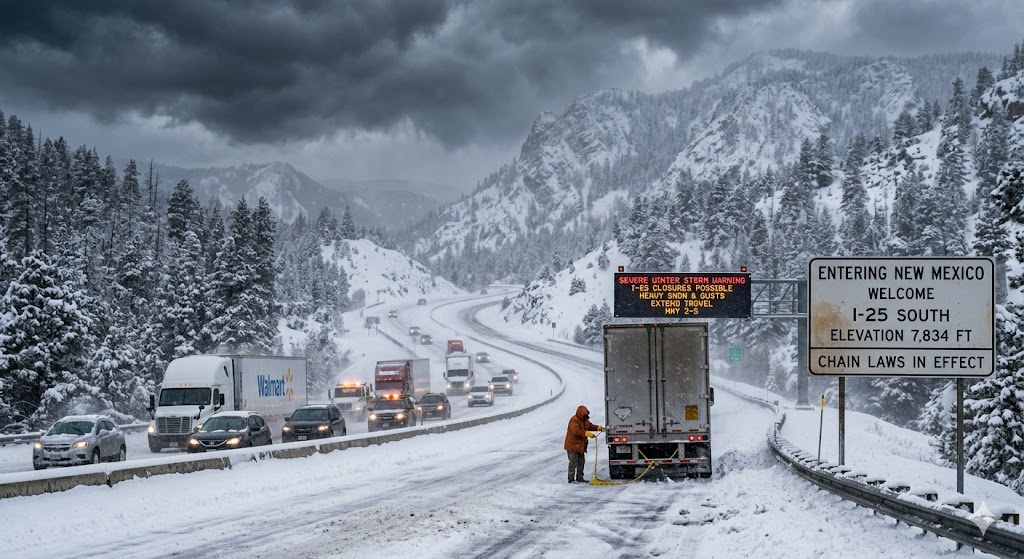
- Inland Tracking: As the system moves east, it is expected to hit Colorado and New Mexico with significant force. I-70 and I-25 in Colorado could see 16-24 inches of snow, while the Sangre de Cristo Mountains in New Mexico are bracing for over a foot of accumulation at higher elevations.
Road Closures and Traction Laws
Caltrans and state transportation officials are bracing for significant disruptions.
- Chain Controls: Strictly enforced for most vehicles travelling above 5,000 feet.
- Traction Laws: In Colorado, the Traction Law remains in force through May 31. Even vehicles equipped with All-Wheel Drive (AWD) or 4WD and snow tyres may be required to carry or use chains depending on the severity of the ice.
- Potential Closures: Officials warn of possible multi-hour closures on both I-80 and Highway 50. Travellers are reminded that when both major routes across the central Sierra shut down simultaneously, there are no realistic alternatives.
Safety Recommendations
The National Weather Service and automotive experts recommend that anyone planning to travel through these regions should:
Prepare an Emergency Kit: Carry chains, blankets, flashlights, portable chargers, water, and non-perishable food.
Maintain a Full Tank: Ensure your vehicle has a full tank of fuel before attempting to cross mountain passes.
Monitor Conditions: Use tools like Caltrans QuickMap or cotrip.org for Colorado to check real-time road conditions and closures before departing.
As this rare May storm moves from California toward Colorado and New Mexico, residents and travellers are urged to remain vigilant and avoid non-essential travel during the peak window from Sunday night through Tuesday morning.
For more such Latest USA breaking news updates, stay tuned with us.
