
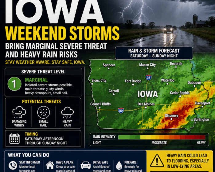
Iowa Weather Alert: Weekend Storms Bring Marginal Severe Threat and Heavy Rain Risks

USA climate news today: What is the Iowa weather alert now? Are the citizens prepared for these weather storms? What insurance coverage claim can they get? As residents across the Hawkeye State clean up from powerful storms that swept through northern and eastern communities, meteorologists warn that the weather pattern is far from over. Following a turbulent Friday that brought high winds, brief tornado warnings, and structural damage to parts of eastern Iowa, a fresh wave of atmospheric instability is poised to impact the region.
Saturday night into Sunday morning brings another significant round of showers and thunderstorms, carrying renewed concerns for damaging winds, hail, and localised flooding.
Weekend Storm Dynamics: What to Expect Across Iowa
The latest weather data from regional meteorologists indicates that a stationary front draped across the Midwest will continue to interact with returning warm, humid air from the south. This setup creates a classic late-summer volatile environment capable of supporting multiple rounds of heavy precipitation and organized convective activity.
-
Primary Threats: The main hazards associated with the upcoming weekend storms include strong, gusty surface winds, small-to-moderate hail, and localised heavy downpours capable of producing brief ponding on roadways.
-
Timing: While parts of the state may experience a relatively dry or hazy Saturday afternoon, scattered storms are expected to fire up after midnight, intensifying into Sunday morning before gradually dissipating past daybreak.
-
Severe Weather Risk Level: The Storm Prediction Center and local forecast offices have maintained a Marginal Risk (Level 1 out of 5) for severe weather across sections of Iowa for Saturday and Sunday.
While widespread, destructive severe weather is not currently guaranteed, atmospheric conditions remain favourable for individual storms to briefly strengthen overnight, prompting potential warnings for travellers and homeowners.
Heavy Rain and Flooding Concerns
Beyond the immediate threat of wind and hail, meteorological models highlight an increasing risk of heavy rainfall. With high atmospheric moisture levels feeding the incoming system, individual thunderstorms will have access to abundant moisture, allowing them to produce highly efficient rain rates.
Of particular concern is a phenomenon known as “storm training”—where multiple thunderstorms repeatedly track over the exact same geographic areas. Central and eastern Iowa remain particularly vulnerable to this scenario, as saturation from Friday’s storms leaves soils with limited capacity to absorb additional water. Residents living in low-lying areas, near small creeks, or prone to urban flash flooding are advised to monitor local river gauges and weather advisories closely.
Recovery and Insurance Preparedness Following Friday’s Damage
The threat of severe weekend weather comes on the heels of destructive storms that struck eastern Iowa counties, including Fayette, Buchanan, and Delaware counties. Local emergency management teams reported structural damage to agricultural infrastructure, downed utility poles, grain bin impacts at regional co-ops, and fallen trees that damaged residential properties.
Such severe weather events serve as a critical reminder for homeowners, commercial property owners, and agricultural producers to review their financial and legal protections. Ensuring that property policies cover wind damage, structural failures, and comprehensive liability is essential for mitigating unexpected losses. For those navigating claims adjustments, legal consultations, or evaluating insurance coverage limits, staying informed on risk management standards remains vital.
Frequently Asked Questions
1. What areas of Iowa face the highest risk for severe weekend storms?
While the overall state remains under a Marginal Risk (Level 1 out of 5), southern, western, and central parts of Iowa face early thunderstorm redevelopment potential, with storms tracking eastward into eastern communities overnight into Sunday morning.
2. What are the primary weather hazards expected overnight?
The main hazards include damaging straight-line wind gusts, frequent cloud-to-ground lightning, isolated large hail, and heavy downpours that could lead to localised flash flooding.
3. How can residents monitor real-time weather conditions?
Weather watchers can track live radar feeds, severe weather alerts, and regional skycams through local network broadcasts or official federal forecasting channels such as the National Weather Service.
4. Where can I find additional breaking news and regional updates?
For continuous updates on local weather patterns, breaking news, financial safety tips, and regional reports across the United States, explore ongoing coverage on usa.freelatestjobalert.com/search.